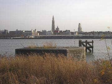
By the morning of Wednesday 23 October 1918, the British Front had reached the River Scheldt, north and south of Tournai. The front was in the western outskirts of Tournai, but the city itself wasn’t yet in British hands.
The British Front had reached the River Scheldt by the morning of 23 October 1918. Adapted from a map accompanying General Haig’s despatches on the final British offensive. Click for larger image. Map credit: IWM/TNA/Great War Digital.
In the six days since 17 October 1918, the front had moved east by 15 miles (24 km). This probably represented the most rapid advance by British troops on the Lys sector.
River Scheldt
The River Scheldt (Escaut in French, Schelde in Dutch) rises at Gouy, near Le Cateau, in the Aisne département of France and flows north through Valenciennes (France) and Tournai (Belgium) to Ghent, where it is joined by the River Lys. Thereafter it continues north to Antwerp, whose citizens it “connects with the rest of the world”, according to a former mayor. After Antwerp it crosses the border into the Netherlands, and flows into the North Sea at Flushing (Vlissingen).
Today was the beginning of the Advance in Flanders, also known as the Battle of the Peaks of Flanders, or the Fifth Battle of Ypres. Ypres – Ieper to its inhibitants – was out of Greg’s sector, but somehow a couple of remarkable aerial photographs of that poor, shattered city came into his hands. Precisely when they were taken, and by whom, isn’t known for certain as they are unmarked. But quite possibly they were taken by Greg when joyriding after the Armistice. We are publishing them today to mark ‘Fifth Ypres’.
Ypres and its Canals
The centre of Ypres is bounded by canals. The widest ones are the Majoorgracht to the west, and the Kasteelgracht to the east. They both arc round to the south of the city centre, where they meet. It is over the Kasteelgracht that the bridge by the Menenpoort (Menin Gate) leads notheast towards Zonnebeke and Passendale, better known to English speakers by its archaic French name of Passchendaele. To the north, the Hoge Weiltjesgracht folds under the Ieperlee, the north-flowing canalised river that drains the land towards the North Sea.
Google Maps satellite view of Ypres/Ieper
Majoorgracht and Pacific Eiland
Near the northwestern end of the Majoorgracht is an island: Pacific Eiland. It is now the home of an inviting restaurant of the same name, whose website explains:
Around 1640 this island was built by the Spanish occupiers to deter the enemy and as ammunition depot. Now it has been transformed into a haven of peace and relaxation where young and old are welcome.
It is indeed now a haven of peace. But in 1918 it was anything but:
Vertical aerial view of Majoorgracht and Pacific Eiland. Click for larger view. Image credit: Gregs War Collection
Here is equivalent view on Google Maps today:
Present day Google maps view of Majoorgracht and Pacific Eiland. Click for larger view
And the view south from Pacific Eiland over the Majoorgracht:
“A haven of peace and relaxation” says the website of the Pacific Eiland restaurant. Today, looking south from the island over the Majoorgracht, it is hard to disagree with that. Research isn’t always arduous. Click for larger view.
Ypres Prison, Ypres Reservoir Cemetery and Minneplein
A second Ypres photograph in Greg’s collection takes in the northwestern part of the city centre. To put it in context, here is a Google Maps satellite view of Ypres, with the field of the photograph edged in white. The arrow shows the edge that will be at the bottom:
Google Maps satellite view of Ypres, with the field of the following photograph outlined. Arrow shows bottom of field.
With that overview in mind, here now is the view in 1918 of the white-edged portion…
Vertical aerial view of Ypres Prison, Reservoir Cemetery and Minneplein, 1918
…and the equivalent view today from Google Maps:
Present day Google maps view of Ypres Prison, Reservoir Cemetery and Minneplein. Click for larger view
Ypres prison – Gevangenis Ieper – is towards the top of the photo, on the right of the centre. In 1918 it was a wrecked building, but the internal panopticon structure beloved by architects of prisons and libraries is clearly visible. The green area in the top right corner is Ypres Reservoir Cemetery, containing 1,579 First World War graves. A school – Campus Minneplein – now occupies part of the open square of Minneplein, on the middle right and bottom right corner. Normal life in Ieper – the city of the elms.