Greg’s run of counter battery patrols continues. This time, clouds both interfere and provide a refuge. Water in the carburettor was a problem.
Log Book
Date: 17.6.18
Hour: 8.20
Machine type: RE8
No.: E27
Observer: Lt Roche
Time: 2 hrs 25 m
Height: 4300
Course/Remarks: CBP. Water in carburettor.
                Engine rough.
Diary
Monday June 17th.  E27.  Counter Battery Patrol.

Very cloudy.  Climbed up above clouds, very pretty but cold.  Hun machines very active.

Dived down through clouds and got in a rain storm.  Too dud to get any information.
Sunday June 16th. E27. CBP. Saw several huns. Dropped four bombs & fired 100 rounds. Sent UL UR UD. Got a lot of water in carb.
“Saw Several Huns” – Albatros C series?
Greg doesn’t record what sort of German aircraft he saw that day. They might have been scouts (fighters), or they may have been Albatros C series reconnaissance/light bombing aircraft (essentially the German equivalent of RE8s) such as this:
Albatros C series (C.III?) reconnaissance aircraft. Credit: Greg’s War Collection.
“Dropped four bombs and fired 100 rounds”
The bombs would have been the nominal 20 lb Cooper bombs featured yesterday. The armaments of the RE8 are given here:
Later in his log book Greg would record the number of bombs dropped and rounds fired, and from which gun, but he hadn’t started doing that at this stage.
“Sent UL UR UD”
Following on from yesterday’s post, in which Greg sent FL FR FD, these were weather signals sent to the squadron’s Central Wireless Station (CWS):
UL: Weather unfit for counterbattery work
UR: Weather unfit for registration [of artillery fire onto a target]
UD: Weather unfit for photography.
And after sending that trio, he no doubt headed for home: retour à Rely.
In other 42 Squadron news, while observing an artillery shoot Capt. Hutchinson and 2nd Lt. Blair were attacked by five hostile aircraft behind enemy lines a couple of miles north of Merville. They survived and returned to Rely unscathed.
Air combat report. Click for larger image.
Time: 7 p.m.
Locality: K.11. sheet 36a N.E.
Pilot: Capt. G. A. Hutchinson
Observer: 2/Lieut. J. Blair

5 Albatros Scouts. D.III.

E.A. came from back of clouds and were within 100 yards of R.E.8. before discovered.  Observer immediately opened fire.  Two of the E.A. then turned off.  After the Observer had fired 100 rounds the remainder turned off and flew East.
Extract of 1:40,000 map of Merville and surrounding area. Square K11 is 3,000 yards (~ 2miles, ~3km) north of the centre of Merville, which is 17 miles (27 km) west of Lille.
On another bumpy day, Greg was on Counter Battery Patrol duty. He dropped his first bomb – a 20lb Cooper bomb – and fired his first shots in anger, but without much success at least in the case of the bomb.
Saturday June 15th. E27. Counter Battery Patrol from 10 to 1 pm. Sent FL FR FD. Very bumpy. Dropped a bomb on a bridge, missed rather badly. Fired off 50 rounds into Hun lines from Vickers gun. Observer fired 100 from Lewis.
“Sent FL FR FD”
This somewhat cryptic sentence in Greg’s diary is in the active voice, not the passive voice. It refers to signals that he sent to the squadron’s Central Wireless Station (CWS), not places to where he might have been sent by them. In fact, they were weather signals:
FL: Weather fit for counterbattery work
FR: Weather fit for registration [of artillery fire onto a target]
FD: Weather fit for photography.
The corresponding ‘unfit’ signals would be UL, UR and UD, respectively.
Friday June 14th. RE 6548. Very windy, about 45 mph. Counter battery patrol 12.30 to 1.30. Fearfully bumpy. Good landing – rather more luck than anything else. Explosion near Merville.
Rely aerodrome certainly would have caught the wind. It is located on what passes for high ground in Artois, south of the Lys – just on the 100 m contour line – whereas the Lys valley around Merville is less than 20 m above sea level. Hence the fearful bumpiness.
After the false starts earlier in the week, Greg starts to ease into what will become one of his routine activities: the Counter Battery Patrol. This one, which at three hours duration was one of the longer ones, was enlivened by some ‘Archie’ – anti-aircraft fire.
Thursday June 13th.  E27. Counter battery patrol from 4 to 7. Rather dud, engine rough.

One ‘Archie’ burst under tail.  Two explosions in Hunland.  Bad landing.  Observer fired off 100 rounds into Calonne.
All the As: Archie, Ack-Ack and Anti-Aircraft Fire
‘Archie’ – anti-aircraft fire. Image: Greg’s War Collection. Click for larger image.
‘Archie’ and ‘ack-ack’ were both slang terms used by British airmen for anti-aircraft fire in the First World War. One is easier to explain than the other.
Ack-ack
Ack-ack’ is the easier term to explain, as ‘Ack’ was the letter A in an early military alphabet, as set out by The Royal Signals Museum here. AA or ack-ack was the standard abbreviation for anti-aircraft (fire).
Archie
But what of ‘Archie’? The most prevalent explanation seems to be that it derived from a popular music hall number called Archibald! Certainly not, first sung by George Robey in 1911. The story is that a pilot used to shout the song title, which was also the refrain, to his observer when an anti-aircraft shell exploded nearby (but missed), and ‘Archibald’ of course became abbreviated to ‘Archie’. Some accounts credit the first usage to Lieutenant Amyas ‘Biffy’ Borton of 5 Sqn RFC.
In a competing explanation, this source has a rather more elaborate account of the origin of the expression, quoting Ernest Weekley’s An Etymological Dictionary of Modern English (1921) :
“It was at once noticed at Brooklands [where much aviation development and testing was carried out prior to 1914, and portrayed in the film Those Magnificent Men in their Flying Machines] that in the vicinity of, or over, water or damp ground, there were disturbances in the air causing bumps or drops to these early pioneers. Some of these ‘remous’ were found to be permanent, one over the Wey river, and another at the corner of the aerodrome next to the sewage-farm. Youth being fond of giving proper names to inanimate objects, the bump near the sewage-farm was called by them Archibald. As subsequently, when war broke out, the effect of having shell bursting near an aeroplane was to produce a ‘remous’ reminding the Brookland trained pilots of their old friend Archibald, they called being shelled ‘being Archied’ for short. Any flying-man who trained at Brooklands before the war will confirm the above statement” (Col. C H Joubert de la Ferté, I M S ret.)
Well, which is right? Either way, you can hear Harry Bluff singing Archibald! Certainly not here:
Calonne
“Observer fired off 100 rounds into Calonne.” Calonne (today, Calonne-sur-la-Lys) is a small settlement 2 miles (3 km) south west of Merville, itself 17 miles (30 km) west of Lille. The German line ran through Calonne and Le Sart, to its north, at the time. Anywhere to the east of this line qualified as ‘Hunland’.
Calonne and Le Sart on a 1:40,000 map. Each square is 1,000 yards. Click for larger image. Map credit: IWM/TNA/GreatWarDigital.
Counter Battery Patrols
For an explanation of what counter battery patrols involved, see this new page in the ‘Setting the Scene – Background Articles’ series:
After yesterday’s adventures, today is a quiet day for Greg with just short flight for a rigging test on E27, which has had its undercarriage repaired overnight:
Header image: a brick and stone farm building on the rue de Liettres by the site of the First World War airfield in Rely must have looked much the same 100 years ago.
On the first day of war flying a week after his crash on 4 June 1918, Greg had a terrible day: he got hopelessly lost (in his own unsparing words), ended up at Bergues, near Dunkirk, and then smashed up his undercarriage in an awful landing (ditto) when he finally made it back to the aerodrome at Rely.
Tuesday June 11th.  Gwen E27. On Counter Battery Patrol, from 7am to 10am.

Went up at 7 & landed again, weather dud.

Clouds at 600ft.

Took off again at 9am & ran into clouds at 300ft over the second line.

Got hopelessly lost; after about an hour’s flying sighted a small aerodrome.  Made a good landing & enquired where I was.  Found I was in Bergues, 6 miles from Dunkirk, Belgium.

After a rest, took off again & followed the main road at about 200ft, via Cassel & St Omer to the drome.

Made an awful landing, smashed the undercarriage.
I don’t know what the reference to “Gwen” signifies. An affectionate name for Greg’s newly assigned aircraft, serial number E27, perhaps?
Bergues
What a day for a novice on the front line. But it wasn’t all bad: at least he didn’t stray over the German line. Bergues is some 5 miles (8 km) SSW of Dunkirk and is in France, not Belgium. The German front line was about 18 miles (26 km) ENE from Bergues, at Rousdamme not far from where it emerged on the coast at Nieuwpoort (both in Belgium).
Perhaps during his rest in Bergues Greg sampled the local cheese that has been made there for centuries and for which the village is still known today.
Fromage de Bergues – purchased from the excellent Comptoir Laitier Fovet in Aire-sur-la-Lys, an essential stop for any cheese aficionado visiting the Pas-de-Calais/Nord region of France
Today, we have no more idea than Greg did as to what course he took on his way to Bergues. It was unlikely to be the straight line shown on this map, but the return journey following the roads via Cassel and St Omer is easier to be confident about:
Getting hopelessly lost and coming home on a modern map (courtesy Google). Click for larger image. Click here to see full Google terrain map (opens in new tab).
Smashing the undercarriage on landing must just have topped his day. He probably wished he hadn’t got up that morning.
In spite of declaring himself fit for war flying, the dud weather awarded Greg another day on the ground:
Diary
Monday June 10th 1918. Pretty dud day; did not fly.
“Dud” was always one of Greg’s favourite adjectives (and nouns) of disapprobation. It was a word that was rapidly rising in popularity during the First World War, as this Ngram graph from Google Books shows:
For an explanation of Ngrams, click here (opens in new tab). This Ngram was generated using the corpus of English books (British and American) between 1800 and 2008.
Greg has deemed himself fit for war flying again, five days after his crash.
Diary
Sunday June 9th 1918. Told Flight Commander that I feel fit for war flying again.
Chaussée Brunehaut
But no flying for Greg that day. Perhaps he spent some time gazing over the airfield. The header image shows the view on a hazy day in June 2018 southwest over the site of Rely airfield from the Rue de Liettres towards the line of trees that mark the Thérouanne-Arras road, today’s D341, marked on some maps as a Chaussée Brunehaut (Brunhaut’s Causeway), which may be Roman in origin, or not – depending on the position you take in the debate. For more, see the Wikipedia entry here (in French, opens in new tab).
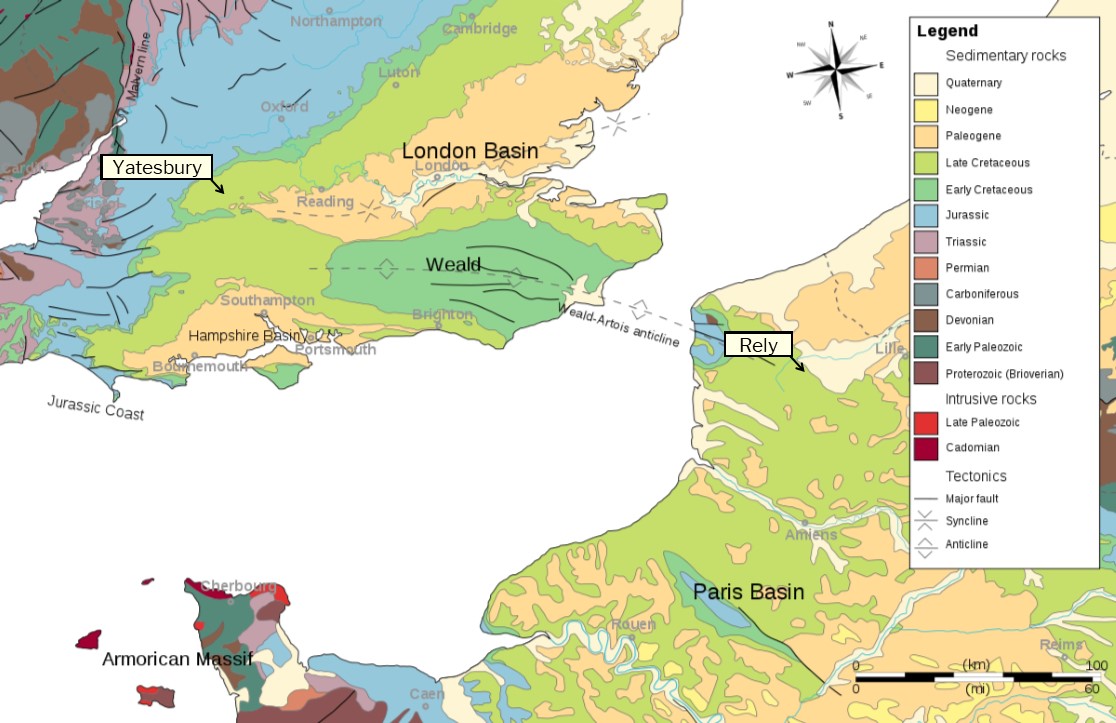
Geology of Rely and Yatesbury
The outlook was and is similar to that looking across Yatesbury airfield , where Greg started flying lessons less than three months ago, except that the distant road in that case was the London-Bath A4. The similarity of outlook isn’t surprising given the geology of Rely and the uplands of Artois on the one hand and Yatesbury and the Marlborough Downs in Wiltshire on the other: they are at opposite ends of the Weald-Artois Anticline and share the same sedimentary rocks of the Late Cretaceous period, as shown in this map:
Map of the Weald-Artois Anticline that provided Greg with a familiar landscape. Click for larger image. More details here. Adapted from original image by Wikipedia user Woudloper/Woodwalker (“a young geologist from Berne, Switzerland”). Licensed under CC BY-SA 3.0.
E102 Returned to Sender
The Squadron CO’s orders for today show that E102, which had come off second best in Greg’s close encounter with a field of crops at Trézennes on 4 June, was struck off the charge of the squadron on 7 June and returned to No 1 ASD. See page 2:
Daily Orders for 9 June, page 1. Click for larger image.
Daily Orders for 9 June, page 2. Click for larger image.
Header image: shows the view on a hazy June day in 2018 southwest over the site of Rely airfield from the Rue de Liettres towards the D341, the Thérouanne-Arras road,