After yesterday’s adventures, today is a quiet day for Greg with just short flight for a rigging test on E27, which has had its undercarriage repaired overnight:
Header image: a brick and stone farm building on the rue de Liettres by the site of the First World War airfield in Rely must have looked much the same 100 years ago.
On the first day of war flying a week after his crash on 4 June 1918, Greg had a terrible day: he got hopelessly lost (in his own unsparing words), ended up at Bergues, near Dunkirk, and then smashed up his undercarriage in an awful landing (ditto) when he finally made it back to the aerodrome at Rely.
Tuesday June 11th.  Gwen E27. On Counter Battery Patrol, from 7am to 10am.

Went up at 7 & landed again, weather dud.

Clouds at 600ft.

Took off again at 9am & ran into clouds at 300ft over the second line.

Got hopelessly lost; after about an hour’s flying sighted a small aerodrome.  Made a good landing & enquired where I was.  Found I was in Bergues, 6 miles from Dunkirk, Belgium.

After a rest, took off again & followed the main road at about 200ft, via Cassel & St Omer to the drome.

Made an awful landing, smashed the undercarriage.
I don’t know what the reference to “Gwen” signifies. An affectionate name for Greg’s newly assigned aircraft, serial number E27, perhaps?
Bergues
What a day for a novice on the front line. But it wasn’t all bad: at least he didn’t stray over the German line. Bergues is some 5 miles (8 km) SSW of Dunkirk and is in France, not Belgium. The German front line was about 18 miles (26 km) ENE from Bergues, at Rousdamme not far from where it emerged on the coast at Nieuwpoort (both in Belgium).
Perhaps during his rest in Bergues Greg sampled the local cheese that has been made there for centuries and for which the village is still known today.
Fromage de Bergues – purchased from the excellent Comptoir Laitier Fovet in Aire-sur-la-Lys, an essential stop for any cheese aficionado visiting the Pas-de-Calais/Nord region of France
Today, we have no more idea than Greg did as to what course he took on his way to Bergues. It was unlikely to be the straight line shown on this map, but the return journey following the roads via Cassel and St Omer is easier to be confident about:
Getting hopelessly lost and coming home on a modern map (courtesy Google). Click for larger image. Click here to see full Google terrain map (opens in new tab).
Smashing the undercarriage on landing must just have topped his day. He probably wished he hadn’t got up that morning.
In spite of declaring himself fit for war flying, the dud weather awarded Greg another day on the ground:
Diary
Monday June 10th 1918. Pretty dud day; did not fly.
“Dud” was always one of Greg’s favourite adjectives (and nouns) of disapprobation. It was a word that was rapidly rising in popularity during the First World War, as this Ngram graph from Google Books shows:
For an explanation of Ngrams, click here (opens in new tab). This Ngram was generated using the corpus of English books (British and American) between 1800 and 2008.
Greg has deemed himself fit for war flying again, five days after his crash.
Diary
Sunday June 9th 1918. Told Flight Commander that I feel fit for war flying again.
Chaussée Brunehaut
But no flying for Greg that day. Perhaps he spent some time gazing over the airfield. The header image shows the view on a hazy day in June 2018 southwest over the site of Rely airfield from the Rue de Liettres towards the line of trees that mark the Thérouanne-Arras road, today’s D341, marked on some maps as a Chaussée Brunehaut (Brunhaut’s Causeway), which may be Roman in origin, or not – depending on the position you take in the debate. For more, see the Wikipedia entry here (in French, opens in new tab).
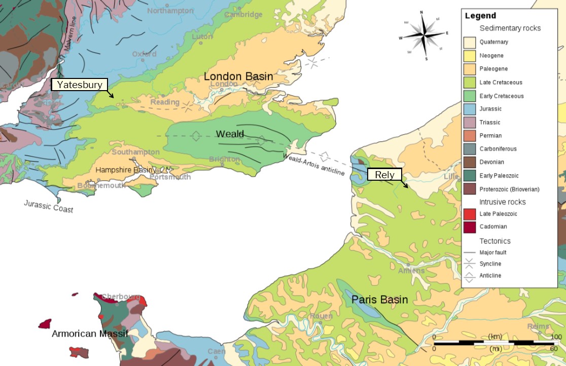
Geology of Rely and Yatesbury
The outlook was and is similar to that looking across Yatesbury airfield , where Greg started flying lessons less than three months ago, except that the distant road in that case was the London-Bath A4. The similarity of outlook isn’t surprising given the geology of Rely and the uplands of Artois on the one hand and Yatesbury and the Marlborough Downs in Wiltshire on the other: they are at opposite ends of the Weald-Artois Anticline and share the same sedimentary rocks of the Late Cretaceous period, as shown in this map:
Map of the Weald-Artois Anticline that provided Greg with a familiar landscape. Click for larger image. More details here. Adapted from original image by Wikipedia user Woudloper/Woodwalker (“a young geologist from Berne, Switzerland”). Licensed under CC BY-SA 3.0.
E102 Returned to Sender
The Squadron CO’s orders for today show that E102, which had come off second best in Greg’s close encounter with a field of crops at Trézennes on 4 June, was struck off the charge of the squadron on 7 June and returned to No 1 ASD. See page 2:
Daily Orders for 9 June, page 1. Click for larger image.
Daily Orders for 9 June, page 2. Click for larger image.
Header image: shows the view on a hazy June day in 2018 southwest over the site of Rely airfield from the Rue de Liettres towards the D341, the Thérouanne-Arras road,
As his shoulder continued to improve, Greg took to the controls again without yet being restored to normal duties. But perhaps the task he was assigned made him wish he was!
Log Book
Date: 8.6.18
Hour: 10.30
Machine type: RE8
No.: E116
Passenger: Lt ?
Time: 5 m
Height: 500
Course: Aiming practice for infantry
Remarks: Engine dud.  Bad landing.
Date: 8.6.18
Hour: 6.45
Machine type: RE8
No.: E116
Passenger: Mechanic
Time: 10 m
Height: 1000
Course: Engine test
Remarks: Engine OK. Good landing.
Diary
Saturday June 18th.  Took up E116 to give Infantry aiming practice with anti-aircraft machine guns.
Took up an infantry officer as passenger.
Engine dud, made a bad landing on aerodrome.
Had new magneto fitted on right hand side of engine.
Took machine up again about 7.pm for engine test, with mechanic as passenger.
Engine apparently OK again.
Good landing.
What a job…
…”to give Infantry aiming practice with anti-aircraft machine guns”? Doesn’t sound like much fun. No doubt Greg hoped that they were good enough not to need much practice. And perhaps the infantry lieutenant whom Greg took up with him was less of a passenger and more of a hostage.
Greg’s recovery continues and he takes to the air again, but only as a passenger with his friend Charlesworth at the controls of Greg’s new aircraft:
Log book
Date: 7.6.18
Remarks: Did not fly
Diary
Friday June 7th 1918. Feeling much better all round. Went up as passenger with Lt Charlesworth, testing engine of RE8 E116 – our new bus. Engine apparently OK.
Still recovering from his close encounter with a field of crops two days ago, Greg spends another day on the ground, probably staying on Rely aerodrome.
Log Book
Date: 6.6.18
Remarks: Did not fly
Diary
Thursday June 6th 1918. No flying for me. Saw Doctor who told me not to fly until Saturday. Shoulder improving.
Rely Aerodrome Then and Now
The site of Rely aerodrome in the Great War was just on the 100 m contour mark on a plateau northwest of the village. The land gently rises up from the Lys and its tributary streams. The airfield lay next to a road running southeast from Thérouanne through Estrée Blanche to Arras in a sufficiently straight line to suggest a Roman origin.
Rely then and now. Extract from 1918 1:40,000 map of Rely airfield in which each numbered square is 1,000 yds (Credit: IWM/TNA/GreatWarDigital) adjacent 2018 Google satellite view (https://goo.gl/maps/dMox5bFWpQ22). Click for larger view.
Rather unsurprisingly after yesterday’s crash, Greg was in some pain and did not fly:
Log Book
Date: 5.6.18
Remarks: Did not fly
Diary
Wednesday June 5th 1918.  Did not fly.  Found I had flattened my nose and blackened my eye.

Shoulder painful.
Daily Orders
On this day of being confined to the ground, 42 Squadron’s CO’s Daily Orders noted that Greg and the three others who came with him from Berck Plage (Cooper, Charlesworth and Mesinger; see link below) were posted to the squadron with effect from 3 June 1918:
Daily orders. Click for larger image.
Greg is allocated the wireless number 48, which he will include in signals from the aircraft to an artillery battery or the Central Wireless Station.
…the grey skies of St Floris have no reflection of the hazards they witnessed in 1918…
St Floris on 4 June 2018, looking west along the road known in 1918 as The Grand National from Hell Fire Corner, and showing the (rebuilt) spire of the church and the skies above. Click for larger image.
…and the ultra-dwarf crops at Trézennes hold no clues of the crash landing 100 years ago this morning from which a lightly damaged 2nd Lt Gregory was extracted.
An entirely troop-free Trézennes has forgotten the events of 100 years ago today, although the red-and-white colours of the right hand pylon stand as a reminder of aerial activity in the area. Click for larger image.
Header image credit: IGN France 1:25k/GreatWarDigital. St Floris is on the extreme right, and Trézennes is on the extreme left.
Meanwhile, the other business of the Squadron continued. Capt. Archer, who was in combat action only two days ago (here), was the pilot, who flew to the (unsuccessful) defence of a balloon – probably a kite balloon – near Steenbecque:
Air combat report. Click for larger image
Time: 4.50 p.m.
Locality: STEENBECQUE
Pilot: Capt. R. A. Archer, M.C.
Observer: Lieut. F. B. Sagar


Saw a hostile Scout flying towards Balloon.  Decided to attack if I got a chance.  E.A. was steering a roundabout course which enabled us to reach Balloon almost as soon as E.A.  Dived on E.A. firing Vickers at him until a No 3 stoppage occurred.  Turned to give Observer a shot and he put in about 50 rounds.  In the meantime the balloon was lit and the E.A. turned home.  Closest range Vickers about 150 yards. Lewis about 200 yards.  E.A. did not appear to try to fire on us.
No 3 Stoppage
According to the Great War Forum’s user Andrew Upton in a post of 20 November 2016, the most common reason for a No 3 (3rd position) stoppage on the Vickers machine gun is a feed fault, but there are other possibilities, including
Insufficient headspace,
Friction in the lock,
Bent or damaged long spacers (every three rounds),
Thick-rimmed cartridge,
Stuck or “frozen” gib, overly stiff gib spring, or roughness or burrs on extractor face, and
Not enough tension on the recoil spring.
Steenbecque
Steenbecque is just north of the Nieppe Forest, 4½ miles (7 km) northwest of Aire-sur-la-Lys:
Map extract of Steenbecque and Aire, from 1:40,000 series. Each numbered square is 1,000 yds. Click for larger image. Credit: IWM/GreatWarDigital